The Cambridge Group of the Ramblers is considering making a claim for two well-used paths in the Wimpole/Orwell area to be added to the ‘Definitive Map’ for Cambridgeshire, using evidence of uninterrupted use by the public for a period of at least 20 years. This claim for a ‘Definitive Map Modification Order’ or DMMO, uses the same legislation as was successfully employed recently to add the footpath up Castle Mound in Cambridge to the public rights of way network.
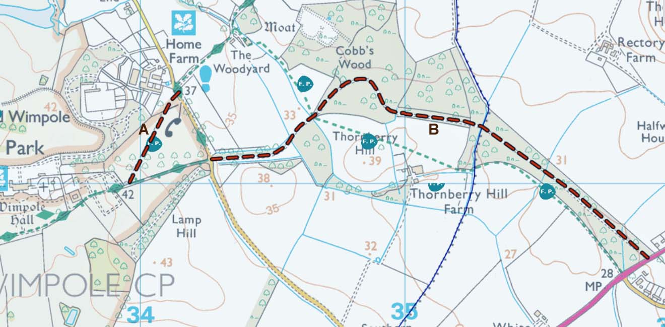
Route A is short and crosses two grassed fields, linking the lane next to Home Farm to the main drive to Wimpole Hall. There are gates at both ends and also one between the fields. Part of the route, running NE to SW, is marked by stones set in the grass. The SW end of the path used to emerge at the east end of the ‘old’ Wimpole Hall car park. The route is very well used by anyone walking to/from the public footpath rising past Cobbs Wood Farm up to the Mare Way and over to the Eversdens. In very recent months the gates have been reported to be padlocked shut. The path is marked on current OS maps as a black-dotted line.
Route B is much longer and is sometimes known as the ‘Victoria Carriage Drive’. It runs between the eastern end of the main drive to Wimpole Hall and then runs east to meet the A603 close to Orwell village. There are metal gates for pedestrians at each end and a wooden gate en-route. The path follows a hard-surfaced track for much of the way and provides a delightful walk, predominantly through woodland. It is clearly marked on OS maps.
Both paths have been highlighted in the ‘Don’t Lose Your Way’ research carried out by the Ramblers Association because there is evidence of their long-term historic use as public paths. But the Cambridge Group believes that there is also evidence of regular, unchallenged and unhindered use in recent years – hence the desire to compile evidence of use since 2001.
You don’t need to have walked one or both paths for twenty years to provide evidence! But what we do need to know is when you have used the path(s) and if you have ever been aware of attempts to stop public access. If you are willing to provide evidence of use then you will need to complete a form and provide a map of where you consider the path(s) run. The Ramblers will provide both the forms and a map which you can print off and trace a route on.
Please contact Jill if you are willing to help add these paths to the public rights of way! She can send you the relevant forms which we need to provide evidence. Her email is:
secretary@cambridgeramblingclub.com
The two routes are shown below